![]()
Legacy of the Incas
Machu Picchu Luxury Tours
Peru:
Machu Picchu - Lake Titicaca
(11 days/10 nights)
Machu Picchu Luxury Tours
Peru:
Machu Picchu - Lake Titicaca
(12 days/11 nights)
Empire of the Sun
Machu Picchu Luxury Tours
Peru:
Machu Picchu - Lake Titicaca
(14 days/13 nights)
Ancient Civilizations of Peru
Machu Picchu Luxury Tours
Peru:
Colca Canyon - Machu Picchu
Lake Titicaca
(16 days/15 nights)
Archaeological & Ecological
Treasures
Machu Picchu Luxury Tours
Peru & Ecuador:
Galapagos - Machu Picchu
Lake Titicaca (or Amazon)
(18 days/17 nights)
Grand Tour of the Inca Empire
Machu Picchu Luxury Tours
Peru:
Colca Canyon - Amazon
Machu Picchu- Lake Titicaca
(22 days/21 nights)
Ancient & Colonial Capitals
Machu Picchu Luxury Tours
Peru:
Machu Picchu
(10 days/9 nights)
Inca Trail to Machu Picchu
Machu Picchu Luxury Tours
Peru:
Machu Picchu
(13 days/12 nights)
Machu Picchu & Galapagos
Machu Picchu Luxury Tours
Peru & Ecuador:
Machu Picchu - Galapagos
(15 days/14 nights)
Galapagos & Machu Picchus
Machu Picchu Luxury Tours
Ecuador & Peru:
Galapagos - Machu Picchu
(18 days/17 nights)
Enchanted Isles of the Galapagos
Machu Picchu Luxury Tours
Ecuador:
Galapagos
(11 days/10 nights)
Galapagos & the Kingdom of Quito
Machu Picchu Luxury Tours
Ecuador:
Galapagos - Andes
(16 days/15 nights)
Galapagos & the Amazon
Machu Picchu Luxury Tours
Ecuador:
Galapagos - Amazon
(16 days/15 nights)
Historic Haciendas of the Andes
Machu Picchu Luxury Tours
Ecuador:
Cotopaxi - Antisana - Otavalo
(7 days/6 nights)
© 2013 Inka's Empire Corporation.
All rights reserved.
![]()
Pre-Departure Information
Machu Picchu Luxury Tours & Travel
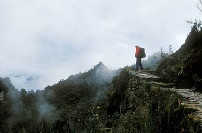
Before Phuyupatamarca, Inca Trail to Machu Picchu.
Photo: Mylene d'Auriol Stoessel. Machu Picchu Luxury Tours & Travel.
Itinerary
Map
Detail Map
Sectional Map
Trail permits
Permission to trek the Inca Trail must be obtained from Peru's National Institute of Culture, which administers the Machu Picchu Historical Sanctuary. Since the number of permits is limited to 500 people (including trekkers, guide, chef and porters) beginning the trek each day, requests should be submitted as early as possible. The following information is required:
- Your full name (exactly as on passport).
- Passport number.
- Country of issue.
- Date of expiration (must be valid for at least six months after your entry into Peru).
- Birthdate (month/day/year).
- Gender.
The expiration date of your passport must be valid for at least six months after your arrival in Peru. If you would like to check on the number of permits currently available for a certain date, you can consult the web site of the Ministry of Culture. Click on the "Consultas" tab, then choose a year and a month to see the number of permits still available on each day of that month. If you trek with Inka's, we will obtain the permits.
Inca Trail Classic: trailhead, distances & altitudes
- Trailhead at Piskakucho (Km. 82)
- Distance: 42 kms.
- For altitudes, see the Sectional Map
Inca Trail Explorer: trailhead, distances & altitudes
- Trailhead at Chillca (Km. 77)
- Distance: 47 kms.
- For altitudes, see the Sectional Map
Sleeping tents.
Photo: Inka's Empire Tours. Machu Picchu Luxury Tours & Travel.
What we include
Personnel
- A licensed, well-trained, English-speaking guide, who will visit you the evening before departure to explain the trek and answer any questions.
- Chef (assisted by one of the porters) preparing healthy, hearty meals cooked with fresh, local ingredients, and offering a vegetarian option upon advance request.
- Well-paid and well-treated porters. We supply the appropriate duffel for you to pack and them to carry. You carry only a light daypack.
- The personnel required for two trekkers is 7: 1 guide, 1 chef, 1 chief porter and 4 porters.
Camping equipment
- Spacious North Face VE 25 tents (a three-person expedition tent but is used for just two trekkers to offer our guests more space and comfort)
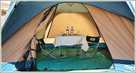
- Dining tent
- Tables and chairs,
- Cooking equipment.
- Oxygen bottle
- A North Face "Snowshoe" sleeping bag with a freshly-cleaned liner, a Therm-a-rest mattress and a pillow.
- A special duffel bag for your gear. In order to ensure the fair treatment of our porters, we require that each person limit this duffel to 22 pounds (10 kilograms). You will be able to leave any excess items at our office or your hotel in Cuzco.
- We lend you ecologically sound hiking poles, approved by the Historical Sanctuary.
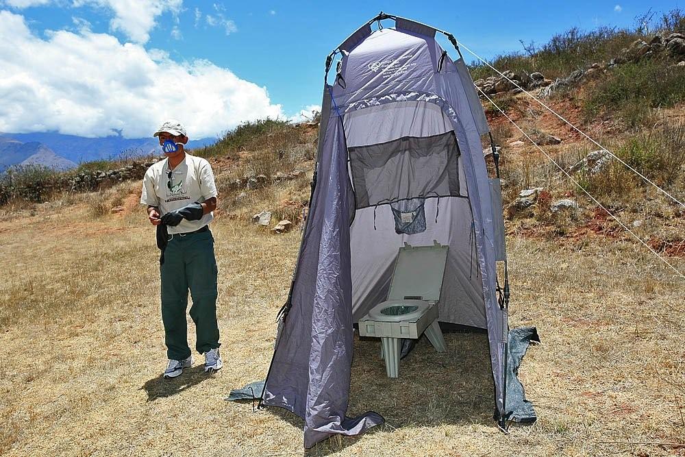
- Tent with a portable environmental toilet
Transportation, entrances and accommodations
- Overland transportation from Cuzco to the start of the trail. For return: bus from Machu Picchu to the town of Aguas Calientes and the Orient-Express Vistadome train from Aguas Calientes to Cuzco. Departure from or return to Ollantaytambo, instead of Cuzco, is optional.
- Entrance tickets for the Inca Trail and Machu Picchu.
- Hotel accommodations in the Orient-Express Sanctuary Lodge, next to the ruins of Machu Picchu, and the Orient-Express Hotel Monasterio, upon return to Cuzco.
If you have selected the Platinum Upgrade
- A relaxing massage and wine at the end of each day on the trail.
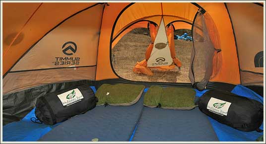
Interior of a sleeping tent with mats, sleeping bags and pillows.
Photo: Inka's Empire Tours. Machu Picchu Luxury Tours & Travel.
What to bring
- A small day pack to carry your sunglasses, sun hat, sun and insect lotion, camera, canteen or non-disposable water bottle, a wind jacket and rain gear.
- One complete change of clothing per day (trousers, socks, T-shirts and underwear).
- Sweater and jacket for cool days or nights, gloves and winter hat recommended.
- Warm sweat pants for evenings around the camp and in the tent.
- North Face or other high-quality trekking boots with ankle support (please break them in well ahead of time), a pair of sneakers to hang out around camp and a pair of flip flops if you choose to take a shower on the last night in Wiñay Wayna.
- Coramina (Glucose). A caramel-like medication to alleviate the symptoms of altitude sickness. Available without a prescription in pharmacies in Cuzco.
- Original passport.
- A flashlight and batteries.
- Personal toiletries and medications.
- Medium-sized towel.
- Peruvian currency (soles) for tips and small purchases along the way (such as cold sodas and shower fee for last night).
- Camera gear (ASA 50, 100 and 200 film recommended), with enough charge/battery power for the duration of the hike.
- Any items you don't need on the Inca Trail but do need at Machu Picchu will be transported by us and waiting at your hotel. Due to limited baggage space on the trains, items you don't need on the Inca Trail or at Machu Picchu should be left at your hotel in Cuzco.
Important considerations for trekking during the rainy season (January - March)
- The day pack should be of a waterproof material (such as Goretek).
- A waterproof rain jacket and rain pants are essential gear that should be in the day pack.
- Rain poncho.
- Warm jacket (down jackets are not recommended because they do not dry readily).
- Nalgene water bottle, which is more resistent to breakage if dropped.
- Leather hiking boots with mink oil treatment.
- Zip lock bags for all cameras, film, batteries, passport and any other items that might be damaged by rain.
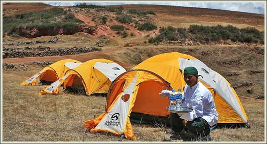
Dining tent.
Photo: Inka's Empire Tours Machu Picchu Luxury Tours & Travel..
Is it safe to drink the water or eat fresh fruit and vegetables?
Disposable water bottles aren't allowed on the Inca Trail. That's because of the trash that would be generated by thousands of plastic bottles being thrown away every day. Accordingly, we gather water from streams along the way, then treat it in a three-step process to assure that it's safe to drink:
1. The water is filtered using Mountain Safety Research technology. 2. The filtered water is purified using Micropur purification tablets. 3. The filtered and purified water is boiled.
This filtered, purified and boiled water undergoes a final treatment with purification tablets so that it will disinfect fresh fruit and vegetables washed with it, Therefore, you can ignore the usual precautions -- we have already taken care of them for you. We are unaware of any guest becoming sick on our treks. Quite the contrary, they are surprised to receive such well-prepared food and drink in such basic conditions.
Toilet tent.
Photo: Inka's Empire Tours. Machu Picchu Luxury Tours & Travel.
Experience required
This is a challenging trek across high altitude passes in the Peruvian Andes.
While no previous trekking or technical climbing experience is required, all trekkers must be in excellent physical condition for this trip. We also suggest that you have some experience with exercise at high altitude. You will be hiking 6 to 7 hours each day, up and down mountain trails that are steep and rocky, and mostly at elevations over 10,000 feet. Porters will carry the bulk of the supplies, but even if you are just carrying a day pack, hiking at high altitude is extremely demanding and can compound physiological stress. You need to be in excellent health and top physical condition to enjoy such an experience, with adequate cardiovascular endurance, muscle strength and excellent balance.
The level of fitness needed requires regular aerobic exercise for at least one hour 4 to 5 times each week. This should include hiking, running and stair climbing, and you must be able to sustain exercise for prolonged periods. We recommend that you start a moderate training program several months prior to departure, then slowly build up to a more strenuous level. Please consult your physician if you have questions concerning your underlying health. We can help answer questions for you and your physician concerning required levels of fitness and health conditions at high altitude.
Trekking at high altitude
There are also inherent dangers in any expedition to high altitude. These dangers include everything from falling rocks and sheer dropoffs to the possibility of a serious fall, accident or sickness without access to a means of rapid evacuation, adequate medical supplies or adequate medical attention once provided. High altitude may create discomfort and symptoms of illness that you do not experience while exercising at low elevations. Anyone planning a difficult mountain trek must be aware of the demands and risks imposed by high altitude, be assured of excellent underlying health and be prepared by rigorous training.
Most trekkers at high altitude feel the physical discomfort of shortness of breath, headaches, nausea, insomnia and exhaustion. Individuals vary widely in their ability to acclimatize and not everyone should go to high altitude. Because physical fitness does not confer any protection or facilitate acclimatization, it is impossible to predict how you will adapt to the altitude. The greatest protection is avoiding rapid ascents and allowing time for your body to acclimatize to the altitude. You must individually pace yourself to go slowly and drink plenty of water to avoid dehydration. You must not push too hard no matter how physically fit you may be or feel.
Early symptoms of high altitude sickness include headache, nausea, loss of appetite, insomnia, vomiting, dry cough, irregular breathing, shortness of breath, fatigue and swelling of the ankles and eyelids. It is not uncommon to experience some of these symptoms when you first arrive at high altitude and then to have them decrease in severity within a few days. For that reason, Inka's Empire Tours strongly recommends spending at least two days at high altitude before beginning the Inca Trail. It is important that you inform your guide immediately of any symptoms or discomfort, however minor, so that he or she can help you monitor the situation. Please be aware that carrying on with the climb in spite of alarm signals from your body may result in serious illness and even death. Medical conditions that are aggravated or complicated by high altitude include heart diseases, lung diseases, pregnancy, anemia and sickle cell disease. It is imperative that anyone with these conditions consult his or her physician in detail before attempting this climbing expedition. Avoid this trek if you suffer from vertigo or a fear of heights.
For more detailed information on altitude sickness and medications that can be taken for its prevention and treatment, please consult the Centers for Disease Control and our Avoiding Altitude Sickness advisory.
Source of "Experience required" and "Trekking at high altitude": Adapted from Yale Educational Travel.
Tipping for the Inca Trail
Suggestions are for two people. If four people, add 50%. We recommend that any tip be given on the last night of camping on the Inca Trail. Once the porters depart the next morning, you will not see them again.
Guide: $65 or S/195
Chef: $25 or S/75*
Chief porter: $15 or S/45*
Porters: $10 or S/30 each*
The personnel required are 1 guide, 1 chef, 1 chief porter and 2 porters per trekker. For example, the personnel required for two trekkers are 7: 1 guide, 1 chef, 1 chief porter and 4 porters. Any tip may be given to the guide for distribution or, if you prefer, you may give any tip to each individual personally.
*Since the chef, chief porter and porters live in the surrounding countryside, it is more convenient for them to receive Nuevo Soles (S/) instead of U.S. dollars.
History
They could have followed the valley but they chose the high route to Machu Picchu, with its gorges and passes and climactic mountain views. True Andean highlanders, the Incas knew and loved the countless natural zones that lay within the folds of their vast domain. Their trail to Machu Picchu traverses a startling variety of microclimates, beginning with an arid cactus zone on the Urubamba valley floor, rising through native Polylepis forest to bleak high-altitude grassland, and ending in mossy cloud forest draped with orchids and bromeliads.
They celebrated the glory of the snow peaks by setting their trail along a ridge that descended from the sacred summit of Salcantay and ended at Machu Picchu. Wherever some astounding view or prominent natural feature captured their imaginations, they built magical stone outposts -- intricate ceremonial settlements of carved stone hewn from the white granite of the region. These cling to mountain spurs, perch on narrow ledges or spill down plunging slopes, with water channels threading among the houses, as though planted there, without human intervention, by an extravagant nature.
All this was abandoned around the time of the Spanish conquest, lying buried beneath the forest until Hiram Bingham set out in 1915 to follow up his discovery of Machu Picchu with a search for the Inca highway leading back to Cusco. Lucky explorer that he was, he found what we now call the Inca Trail and all the sites along it except Wiñay Wayna, that was not discovered until 1941, by Paul Fejos. Today we can hike this trail, seeing much of it intact and easy to imagine as it was in Inca times.
Archaeology
The superbly-built Inca Trail crosses dense forest and deep canyons. There are 18 archaeological complexes dotted along the trail, which can be seen in all their splendor. These consist of housing, irrigation canals, agricultural terracing, walls and shrines, which are irrefutable proof of the existence of important human settlements. This Inca cultural heritage and its environment is protected within the Machu Picchu Historical Sanctuary.
Principal archaeological sites along the Inca Trail
Llaqtapata. "Terrace Town". This settlement was taken over from pre-Inca people and expanded by the Incas, almost certainly as a center of food production for supplying the Inca Trail sites and Machu Picchu itself. Though well planned and constructed, most of the architecture is utilitarian and repetitive in style.
Runkuracay. "Egg Hut", referring to the ovoid shape of the towers. A small site about halfway up the climb to the second pass, it overlooks the Pacamayo valley with a superb view back to the first pass, Warmiwañusca. It was probably built as a lookout point for watching the highway, and perhaps also as a tambo (a traveler's lodging) and temporary storehouse.
Sayaqmarca. "Inaccessible Town" in Quechua -- and the site fits its name. Built on a narrow spur jutting westward below the second pass, it commands a sweeping vista of the Aobamba valley and the route ahead all the way to the third pass, while in clear weather the snow peaks of the Pumasillo massif fill the horizon to the west.
Phuyupatamarca. This "Cloud-Level Town" stands where the trail crosses from south to north of the long ridge leading to Machu Picchu. It is overlooked by flat-topped peaks whose Inca platforms were built for viewing a breathtaking panorama of snow peaks.
Intipata. "Sun Terraces". This is a mainly agricultural complex with a small residential sector, probably built to supplement the food supply to Machu Picchu.
Wiñay Wayna. "Forever Young" -- the name of a perennially flowering orchid formerly abundant in this area. An imposing curved wall culminates in a temple whose doorway faces the snow peak of Wakay Willka (Verónica). With its chain of ceremonial baths, its intricate maze of houses, temples and workshops, its towering waterfall, and the serene sculpture of its terracing, nothing can compare with the intimate magic of this Inca settlement.
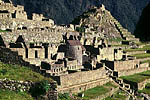
Machu Picchu. "Old Peak". Built as a "royal estate" for the Inca emperor Pachacuti, Machu Picchu is an astounding and perennially mysterious climax to one of the world's most famous journeys: the Inca Trail. Perched high above a sinuous bend in the Urubamba River, Machu Picchu has lured explorers, poets and pilgrims to its mist-wreathed ridgetop ever since its discovery by the American explorer Hiram Bingham in July, 1911.
No one lived here before the Incas. Those mighty empire builders from Cusco discovered this extraordinary place, finding it rich in natural features sacred to their religion. Both inspired and humbled by its dramatic natural beauty, their answer was to create on a vast scale one of the planet's most sensitive and harmonious works of art. The aesthetic genius of its layout and architecture coupled with the durability of its brilliant planning and engineering have given us today this finest of jewels among the UNESCO world heritage sites.
Scholars still argue about the meaning of Machu Picchu: why it was built and what purpose it served, who lived there and when they departed. Most agree that its main intent was spiritual and ceremonial. But clearly its creator, Pachacuti, intended the journey to his sacred city to be a powerful experience in its own right, a pilgrimage whose effort is stunningly rewarded time and again as one follows its winding way among peaks, forests, deep gorges and fairytale ruins. Perhaps if one is to experience the spirit that inspired the builders of Machu Picchu, one truly must walk the length of Pachacuti's white granite highway -- today's Inca Trail.
Landscape
The natural surroundings are impressive and the balance achieved between nature and Inca architecture is striking. The Vilcabamba mountain range boasts peaks higher than 6,000 meters, such as Salkantay and Huamantay, among others. The blend of mountains, jungles and valleys creates a fantasy world where the spectacular dawn and sunset are shrouded in mystery.
Flora
The large natural areas are filled with a variety of forest species which vary according to the habitat. The forest vegetation is represented by trees such as cedar, romerillo or intimpa, laurel and others. There are also species like Ocotea, Pedocarpus, Guarca, Weinmania, Clusia, Cedropia, Cinchena, Eritrina or Pisonay, and Ilex, among others.
The decorative plants have made the Sanctuary famous. Experts have identified more than 90 species of orchids, and many species of begonias and payu cacti. Most of the area is covered by herbaceous, shrub-like and arboreal plants. The varied conditions have created an ideal environment for the growth of diverse plant life -- from thick jungle, like the cloud forest, to the sparsely-covered mountain tops,
Fauna
Animals are abundant and varied. The existence of species in danger of extinction, such as the spectacled bear (Termarctos Omatus), the Cock-of-the-Rock (Rupicola Peruviana), the dwarf deer (Pudu Mephistopheles) and others was one of the reasons that the government decided to protect this area.
The Historical Sanctuary includes species like the puma, Andean fox, river otter, Taruka (Huemul deer), wildcat, ferret and others. There are birds like the Cara Cara, hummingbird, torrent duck, parrot, wild turkey and many other colorful smaller birds. There are also reptiles like the Jergon Bothrops and the coral micrurus snake (lethal for its venom), lizards, frogs, and numerous other Andean and jungle fauna that inhabit the park. This abundant wildlife makes the Sanctuary ideal for tourists and researchers who wish to watch or study the animals.
Climate and environment
The climate is relatively mild all year round with heavy rains from January through March, dry and hot weather from April through October, and temperate with occasional rains in November and December. April through December is the recommended time to visit. The annual minimum temperature oscillates between 8 degrees and 11.2 degrees C (46 to 52 degrees F). In the months of June, July and August the temperature can drop below 0 C (32 degrees F). The annual maximum temperature varies between 20.4 and 26.6 degrees C (69 and 80 degrees F).
The terrain is fairly jagged, with many gullies and glacier-fed streams that eventually pour into the Urubamba River. The river, which has formed a deep valley running through the granite base of the Vilcabamba mountain range, crosses the area for more than 40 kilometers and passes through a variety of ecosystems.
Source: Adapted from PromPeru, The Inca Trail
© 2013 Inka's Empire Corporation, Machu Picchu Luxury Tours. All rights reserved.
